Ordnance Survey is a highly-regarded mapping institution, especially in the UK, but its OS Trail 2 Bike GPS computer is relatively new to the market and marks an advance into Garmin and Wahoo’s current dominance in the bike computer domain.
- Best bike computer in 2020 | GPS cycle computers for riding, training, touring and navigation
- Best mountain bike 2020: how to choose the right one for you
How good is the OS Trail 2 Bike GPS computer?
Touted as a do-it-all GPS bike computer, the OS Trail 2 Bike has in-built navigation, mapping for the whole of the UK, connectivity for heart rate, cadence and speed sensors, and is claimed to track and record up to 120 different bits of data from your ride.
Ordnance Survey has developed its own route and ride software called Go Cloud TwoNav that can be synced with Strava.
The unit boasts an IP67 water- and dust-proof rating and has up to 20 hours of claimed battery life.
OS Trail 2 Bike GPS setup and app functionality
Initial set up for the device was relatively easy and didn’t require a deep read of the online-only instruction manual, which was lucky because the instruction manual isn’t as easy to use as the GPS itself.
Two different web-based logins need to be created before you can use all of the device’s features: one to register it on the ordnancesurvey.co.uk website, which can unlock additional and free-to-download mapping, and a second on the Go Cloud TwoNav website that lets you manage the routes saved to the device and analyses the rides you have recorded.
It’s a pain having to create multiple user logins just to get one device set up, it would be nice to see the setup and device management functions in once place.
The device has its own WiFi connectivity and syncs over the air. Syncing was easy and automatic as soon as it recognised a nearby WiFi connection, and rides showed up on the Go Cloud TwoNav site instantly. If Strava pairing is authorised, your activities will sync automatically with the popular ride tracking website.
In the same vein, routes can be synced with the device over the air once they’ve been uploaded to the Go Cloud TwoNav website, and on-device waypoint creation can be used to create a rudimentary route. It’s also possible to upload routes to the device from your computer via the USB port, but I struggled to get this to work on my MacBook running OS 10.14.6.
There is no phone-based app, which means route creation and uploading relies heavily on the assumption you have a compatible computer with internet access. And while the Go Cloud TwoNav site can be accessed using your phone’s web browser, uploading a saved .gpx file isn’t easy from a mobile.
Overall, I found the setup and accompanying software relatively easy to use but there are some frustrating quirks, such as the need to create user accounts and sign in to multiple websites just to access the device’s full feature-set.
It’s also unclear how to use the device as an external hard drive and upload routes using a USB connection.
OS Trail 2 Bike GPS connected features
The device has a function called SeeMe technology that shares your location with anyone with the correct URL link and alerts them if you get in trouble via a text message and email.
I found this feature relatively easy to set up, but for it to work it relies on you being conscious and able to operate the device to send out an emergency alert. It’s also a subscription-based service and after the first six months, which are free, you will need to pay to continue using it.
I certainly felt that while this feature is well-intentioned, it's more like a gimmick than something you’d regularly use. Most modern smartphones have a ‘find my friends’ function that performs similarly and doesn’t rely on a subscription.
OS Trail 2 Bike GPS satellite tracking accuracy
The device uses GPS, Galileo and GLONASS satellites to locate you on your ride. The route tracking proved to be impressively accurate compared to multiple other devices and it managed to differentiate between small deviations in the path ridden, even in deep woodland or cavernous valleys, rather than drawing inaccurate lines across the map.
Satellite signal took between 1 and 3 minutes to acquire and once signal was found, it very rarely dropped out.
OS Trail 2 Bike GPS ease of use
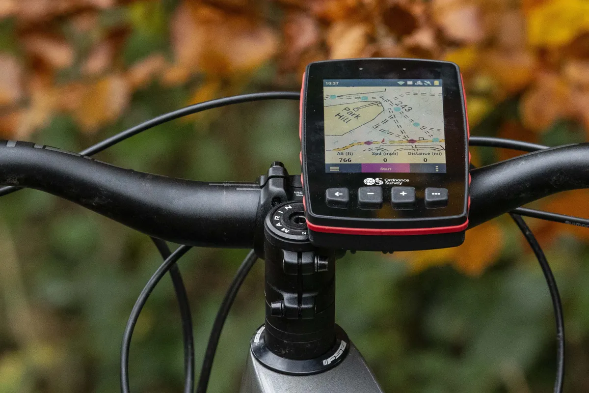
The device’s capacitive 3.7in touchscreen was responsive to light touches and because of its size was relatively easy to scroll, even with gloves on. It didn’t appear to get affected by water droplets as badly as some other touchscreen devices can, either.
However, because of the size of the on-screen text and sheer sensitivity of the screen, it is possible to make regular erroneous menu selections, especially when you’re moving and if there are multiple selectable options on-screen.
This can create a frustrating experience because frequent stops will be required to accurately control the device. Switching between ride recording display screens was trouble-free, however.
At maximum brightness the screen was clear and the colours vibrant. I had no issues with the contrast levels and on sunny days the map and other data screens were easy to view.
The device has six physical buttons: one to sleep the display; one to turn the device on and off; and four buttons that can be in used in lieu of the touchscreen, offering the same functionality.
In reality, I found the buttons hard to use, especially when riding. They’ve got a stiff push-feel and I found myself needing to stabilise the device with my other hand to use the buttons when stopped or on the move, rendering their usefulness non-existent.
Because the device weighs a chunky 243g and the supplied mount relies on rubber O-rings to clamp to the bars or stem, it wobbles around and is easily moved with the firm pushes required to activate the buttons.
Although the mount is claimed to be designed for stems, it’s not possible to attach it to short stems. Luckily it works on the bars, and if your bike’s top tube is small enough it should fit there as well.

Ordnance Survey does sell other mounts on its site, and an out-front option will set you back an additional £29.99. Because of the rather steep £400 asking price for the OS Trail 2 Bike GPS, I had hoped that the supplied mount would be better or more options would be supplied as standard.
OS Trail 2 Bike GPS route finding, navigation and mapping performance
To activate an uploaded route on the device was straightforward, requiring a few simple pushes and scrolls around the touchscreen menus. The route then appears on the on-device map and remains there once you start recording your ride for navigation.
While you’re recording a ride and using the navigation function it’s possible to change to a different route or add an additional one without having to stop recording your current activity. This is a great feature if your plans change or you need to go somewhere else.
On-device navigation employs the use of a coloured line along your set route, superimposed over the top of the map. This means there’s no turn-by-turn navigation or off-route re-routing.
However, if you deviate from the set track, the device flashes up a message with a straight line pointing in the direction of the last place you were on the route. This line is easy to follow but the incessant notifications reminding you that you’ve deviated from your plans did get annoying.
One of the device’s biggest disappointments is the lack of map detail with the pre-installed 1:50k maps. The best way to describe the on-screen map is to imagine a digitalised version of a physical OS map, which means that, unsurprisingly, detail is fairly limited.
Six 25 x 25km 1:25k scale tiles are downloadable for free, and they do offer more detail, but still show no trail centre trails. After exhausting your six free tiles, you’ll need to pay £5 for each map tile to expand your on-device collection.
If you ride across the UK this could be quite a costly upgrade process, considering the device costs £400 to begin with.
Zooming in to carefully study the direction of a route – especially if you’re presented with a crossroads of trails and junctions – made the map detail become rather confusing. For example, the black dashes that denote an unpaved track became so large they no longer represented anything useful.
Similarly, dashes for bridleways became cumbersomely large on the device’s screen making it possible to interpret them as something entirely different.
The zoom function didn’t appear to operate intelligently and scale map details accordingly. Instead, it just increased their size on the screen in a similar way to how zooming in on a basic jpeg image on a computer screen looks.
Devices that use OpenStreetMap provide much greater detail and include details such as mountain bike tracks. OS map data doesn’t have this level of granular information, rendering it fairly incompatible with your average trail centre rider.
The device is useful if you’re bridleway bashing, but if you’re hoping to use it to discover waymarked but lesser-known or wilder routes then you’re going to be disappointed.
The lack of detail on the maps really begs the question whether it’s worth all of the hassle to use the OS proprietary software and device for relatively little benefit.
The display fields while recording my ride were vast and entirely customisable, with more datasets than I could use. Although time and time again, I defaulted to the essentials: altitude gained and current altitude, distance travelled and speed. For those who are into their statistics, it is nice to have the option to display almost any conceivable level of data, however.
A note to hardcopy OS map lovers
MBUK’s Big Ride route gurus Max Darkins and Russell Burton regularly rely on the OS Trail 2 Bike GPS to navigate their rides and raised the point that the details represented on the OS maps (buildings, contours, spot heights, pylons etc.) all aid with in-the-wild navigation.
OpenStreetMaps lacks some of these details, particularly contours, so out of bounds adventurers who like bike orienteering might prefer using the OS device over an OSM-based GPS.
OS maps are regarded as world-leading for navigation and while I agree with that evaluation, if you’re looking to navigate roads, tracks, bridleways and footpaths, the way they’ve been translated to this digital format doesn’t quite work from the perspective of a mountain biker.
This is especially true if you’re a trail centre fan or follow a pre-defined GPS route, and you’ll appreciate the extra detail on OSM maps in these scenarios.
I’m not criticising the accuracy of the OS maps, they’re renowned for being exceedingly good, but I’m more concerned with how MTB-specific details aren’t represented in any way in OS’s on-device adaptation of its popular paper maps.
OS Trail 2 Bike GPS battery life
The impressive claimed 20-hour battery life lived up to my expectations with the device lasting around 17 hours with conservative use – not scrolling through screens often and turning the display brightness down when I wasn’t using the navigation function.
OS Trail 2 Bike GPS bottom line
Unfortunately, the OS Trail 2 Bike GPS's redeeming features – screen brightness, deep data field customisation and impressive battery life – aren't enough to persuade me to consider it over the slightly cheaper Garmin Edge or comparatively budget Polar V650.
The device’s weight, the (at times) tricky to use touchscreen and hefty buttons, high price, lack of map detail and intelligent map zooming, along with the multiple sign-in setup process, all make it tricky and unintuitive to use from the get-go. Add in the terrible bar/stem mount and the device doesn’t fare well with the competition.
And while Ordnance Survey certainly has a reputable pedigree for providing exceptional physical maps, this hasn’t translated in to a copy and paste success in the digital world where OpenStreetMaps still appears to trump all.
If you’re looking to spend £400 on a GPS bike computer and navigation device, I’d recommend looking elsewhere.
Product
| Brand | ordnancesurvey |
| Price | 399.99 GBP |
| br_whatWeTested | OS Trail 2 Bike GPS with 1:50k full GB mapping |
| Weight | 243.0000, GRAM () - |
Features
| br_stravaLiveSegments | no |
| br_rechargeableBattery | yes |
| br_turnByTurnNavigation | no |
| br_smartphoneNotifications | no |
| br_screenType | colour |
| br_screenType | touchscreen |
| br_connectivity | antPlus |
| br_connectivity | bluetooth |
| br_connectivity | wifi |
| br_maps | 1:50k Landranger GB mapping included, 6 OS 1:25K Explorer maps redeemable |
| br_dimensions | 80mm X 131mm X 20mm |
| br_batteryLife | 20 hours |
| br_waterResistance | IP67 |
| br_screenDimensions | 640 X 480 pixles |
| br_displayResolution | 640 X 480 pixles |
| br_sensorCompatibility | Bluetooth, ANT+ |
| Features | Mapping, route guidance, ride recording, 1:50k Landranger GB mapping included, IP67 water- and dust-proof rating |